About the Boise De Sioux Watershed District
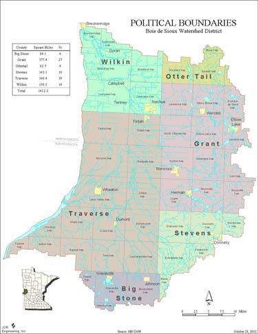
The Bois de Sioux Watershed District (District) was established on May 11, 1988, by order of the Minnesota Board of Water and Soil Resources (BWSR) under the provisions of the Minnesota Statutes (MS), Chapter 103D, otherwise referred to as the Minnesota Watershed Act. The District is located in west central Minnesota and includes the entire drainage basin, in Minnesota, of the Bois de Sioux River. The counties included in this area are Traverse, Grant, Wilkin, Stevens, Big Stone and Otter Tail. Cities within the District are Breckenridge, Doran, Campbell, Wendell, Elbow Lake, Norcross, Herman, Donnelly, Graceville, Dumont, Johnson, Wheaton and Tintah.
The total area is about 1,412 square miles of which 93 percent is used for agricultural production. The Bois de Sioux River and its source, Lake Traverse, form the boundary between Minnesota and South and North Dakota. The river flows north from Lake Traverse to Breckenridge where it joins with the Otter Tail River to form the Red River of the North. Major tributaries in Minnesota are the Mustinka River and the Rabbit River. Tributaries in North and South Dakota contribute drainage from an additional 549 square miles. The District is a governmental subdivision of the State of Minnesota with authority to comprehensively manage water resources.